Fusarium Head Blight Risk Mapping Tool
Displaying the risk of FHB damage to Western Canadian cereals based on weather conditions.
Use Risk Mapping ToolPurpose
To provide advanced assessment of potential FHB damage to Western Canadian cereal crops based on weather conditions and inform fungicide control decisions.

Customize map
View specific FHB damage estimates within your area of interest in Western Canada.

Analyze Risk
Get modeled estimates of potential FHB damage based on weather conditions.

Export insights
Use potential FHB damage estimates for research and farming.
FHB risk parameters
These are quantifiable measures of fusarium head blight pressure and its effects on cereal crops.
FHB Index
FHB Index (FHBi) is the prevalence of the disease as measured in the field during the filling stage of crop development. It is the average percentage of infected kernels per infected head multiplied by the average percentage of infected heads in the field.
Fusarium-damaged kernels
Fusarium-damaged kernels (FDK) result from FHB infection in cereals and cause grain that is chalky and lightweight. It is a grading factor in cereal crops and reported as the percentage of fusarium-infected kernels in a grain sample.
Deoxynivalenol
Deoxynivalenol (DON) is a common mycotoxin produced in FHB-infected cereals. It is measured using the enzyme-linked immunosorbent assay (ELISA) method to determine the amount (ppm) that is present in a grain sample.
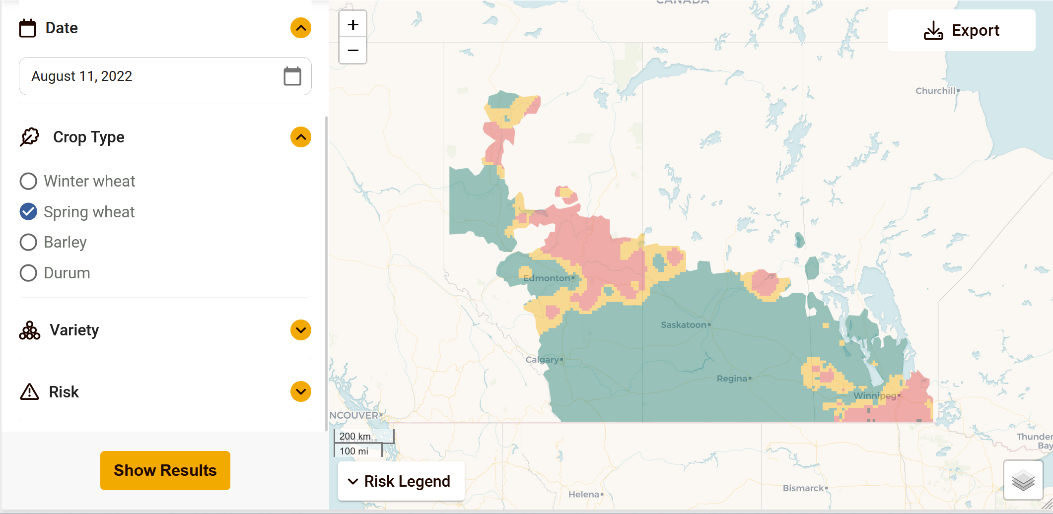
How it works
- 1
Select your map view
Select a FHB Risk parameter, date, crop and variety to specify estimates of interest to you.
- 2
View FHB Risk map
Get a map view of the risk estimates of interest to you.
- 3
Download your map
Once you have a map with the risk estimates of interest to you, download or print the map.
Funding partners
This project was funded from April 2018 to March 2023 through the AgriScience Program as part of the Canadian Agricultural Partnership, a federal, provincial, territorial initiative.


Ongoing funding from April 2023 to March 2026 provided by the Sustainable Canadian Agricultural Partnership (Canada-Manitoba Bilateral Agreement).
Sustainable Canadian Agricultural Partnership Project Funders

Sustainable Canadian Agricultural Partnership Project Supporters

Weather data providers
Weather data used for modeling is provided by Environment and Climate Change Canada; Alberta Agriculture and Forestry; Manitoba Agriculture Weather Program; Saskatchewan Public Safety Agency; and Metos Canada.